 |
Coastal Marine Environments of the MR El Pelado, Santa Elena, Ecuador
|
| Ambientes Marino-Costeros de la RM El Pelado, Santa Elena, Ecuador |
| |
This work is supported by SENESCYT through the project: "Characterization of the microbial and invertebrate biodiversity in the marine Marine Protect Area El Pelado including taxonomic, metabolomics and metagenomics scales, for use in human and animal health (PIC-14-CENAIM-001)" and the Prometheus Program |
|
|
| Areas |
| |
|
|
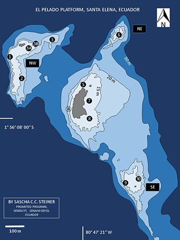
The El Pelado Platform is comprised of four rocky mounds surrounded by soft sediments. The mounds are here referred to as Pelado C (the islet) Pelado NW, Pelado NE and Pelado SE (Steiner 2016).
Ten sites were surveyed for this project (see encircled numbres, image left). Sites 3 and 4 were only surveyed qualitatively, all others also quantitatively. Western slopes are generally steep and occasionally eroded along stratification boundaries, while eastern slopes drop gradually. Substrate-habitat zones (biological zonation bands) thus cover a larger area on eastern slopes of the rocky mounds than on western slopes.
From the shallows towards 30m depth the following main substrate-habitat zones can differentiated by divers: the Balanus Zone, the Turf Zone, the Muricea Zone and the Sandy Zone which covers most of the terrain in 25 to 30m depth. Other substrate-habitat types, such as the Pocillopora Zone are rather patchy in their distribution, and primarily associated to the leeward side of the islet.
For preliminary habitat descriptions from the coast click on the following link: CZ AYANGUE
|
| |
|
| North West |
Site 1. 1°55’58.25’’S 80°47’32.83’’W
Site 2. 1°56’01.35’’S 80°47’31.94’’W
Site 3. 1°55’54.93’’S 80°47’26.36’’W |
Site 3A. 1°55’56.86’’S 80°47’30.46’’W
Site 3B. 1°55’56.42’’S 80°47’29.28’’W |
|
Sites 1, 2, 3A and 3B are part of the same rocky mound, but experience different wave exposures. Sites 1 and 3B have steep drops with narrow substrate-habitat type bands. However, site 3B is structurally more complex providing a greater variety of micro habitats which is reflected in the diversity of sessile invertebrates that are fund at this site. Sites 2 and 3A are partially within the turf zone and have a primarily homogenous terrain. Site 3, at depths starting at 55ft, is the least well studied. A comparatively high diversity of sessile cnidarians (Scleractinia, Alcyonacae) was noted during exploratory dives at this location.
|
| North East |
|
Site 6. 1°55’53.10’’S 80°47’14.25’’W
Site 6 is referred to a San Ignacio by local fishermen. This completely submerged mound is no shallower than 12 m. Its shallow portions fall within the Balanus Zone. Rounded rocks are characteristic for this site and indicates periodic mechanical turning. The Muricea Zone is well developed along the circumference of the mound at depths of 15 m and more.
|
| Central (Islote el Pelado) |
|
Site 5. 1°56’00.59’’S 80°47’19.35’’W
Site 7. 1°56’05.92’’S 80°47’19.74’’W
Site 8. 1°56’10.20’’S 80°47’20.12’’W
The islet or "Islote El Pelado". It lacks vegetation and is a nesting ground for blue footed boobies. Sea lions also use this spot. The islet is the most popular of the recreational dive and snorkeling sites as it provides some protection from the surge and is in the immediate vicinity of a ship wreck. Site 5 is characterized by a Pocillopora assemblages in a structurally moderately complex setting. Coral rubble accumulations are typical, thus creating a rather large interstitial space for invertebrates. Site 7 is the post protected site in the area. Its rocky base (approximately up to 15m depth) provides the stability for Pocillopora assemblages. Coralline and turf zones dominate this area which drops to sandy habitats in the east.The coral cover is found to the north and south of the mooring. Site 8 is the structurally the most complex site. The turf and Muricea Zones are best developed.
|
| South East |
|
Site 9. 1°56’20.25’’S 80°47’12.65’’W
Site 10. 1°56’17.58’’S 80°47’12.01’’W
This mound is also known a "El Cuarenta". The southeasterly inclination in the stratification of sedimentary deposits is best seen at this location. Site 9 follows the western drop offs, in which the Muricea Zone is most characteristic. Site 10 is primarily in the Turf Zone, with a rather plane terrain and homogenous benthic cover dominated by filamentous turf algae that have accumulated calcareous sediments, primarily from mollusks and echinoderms.
|
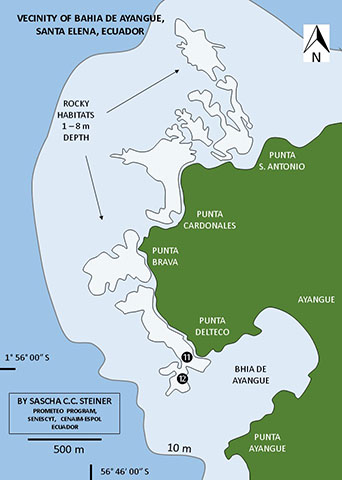
| Coastal Zone Near Ayangue |
|
|
Site 11 1°58’57.82’’S 80°45’39.16’’W
Site 12 1°59’01.84’’S 80°45’37.10’’W
Scattered rocky formations characterize the sea floor to the north of the Punta Delteco. Large slabs and boulders are strewn up to up to 100 m from shore. Primarily near Punta Delteco.
Unlike the substrate-habitat types near El Pelado, encrusting Actinaria and Zoatharia are among the most conspicuous invertebrates and they dominate the live organism cover.
Pocillopora patches intermittently line the breaker zones at site 11 in the areas between Punta San Antonio and Punta Cardonales. Further off shore, rock bases are overgrowth my filamentous turf algae and sediment deposits. Otherwise the coast is characterized by sandy environments. Coarse shell fragments as ar EPP are not as noticeable. Sands are finer and contain terrigenous inputs.
|
|
|